Information on this page has been provided by the Environment Agency and was correct at the time of upload. The Flood Hub is not responsible for any information held on this page. For any enquiries, see the Contact section of the page.
The Carlisle Flood Risk Management Scheme will be delivered in three phases. These pages describe the second of these phases. The work delivered in this phase provides further flood protection to the heart of the city of Carlisle including important transport infrastructure, commercial and leisure facilities as well as residential properties. This scheme reduces flood risk to 50 residential homes and a further 33 other properties including the Sands Centre and Civic Centre. It also reduces flood risk to Hardwicke Circus, Castle Way and the A7 over Eden Bridge providing much more resilience to the city’s key transport routes.
Construction work for phase 2 of the Carlisle Flood Risk Management Scheme included both raising and extending the pre-existing flood defences to a level that provides protection from future flood events as large as those which followed Storm Desmond in December 2015.
The flood defences form a continuous line of defence extending from the playing fields of Trinity School in the east (which are significantly higher than the peak flood levels from December 2015) to the high ground of the Castle in the west. The scheme includes almost 1,000m of flood defences comprising a combination of flood walls, embankments, flood gates and a raised road. To assist with the planning and delivery of this scheme it was divided into 10 distinct areas (ground investigation works confirmed that no works are required in area 1). The map below shows the extent and location of each of these areas, and the sections below describe the works in each area in more detail.

An aerial photo of Carlisle during flooding
Details of the works planned for each of these areas can be found in the ‘Area’ sections in the left hand side menu of this page.

A map showing the 10 areas of the Carlisle Phase 2 flood scheme
The Environment Agency started construction work on phase 2 of the Carlisle Flood Risk Management Scheme in August 2020 and the scheme was watertight by the end of April 2021. The table below provides some key dates.
| Milestone | Date | Status |
| Receive funding approval to construct phase 2 of the Carlisle Flood Risk Management Scheme. | Late July 2020 | Complete |
| Submit planning application for four specific areas of construction. | Late August 2020 | Complete |
| Set up construction compounds in the Swifts car park and Bitts car park and prepare construction sites. | Early August 2020 | Complete |
| Start construction work*. | Late August 2020 | Complete |
| Complete construction work and remove compounds. | End of April 2021 | Complete |
| Final testing, confirmatory surveys and resolving any outstanding issues. | Autumn 2021 | Ongoing |
*Construction work started initially in a number of areas that did not require planning permission.
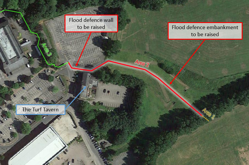
Within area 2 the main piece of construction work was raising the Swifts flood defence embankment by 0.2m, this raised embankment ties into the higher ground levels of Trinity School playing fields and the existing high flood defence wall adjacent to the Turf Tavern. As part of these embankment works the Environment Agency also made improvements to their access track alongside this embankment; this will help their field teams maintain this defence in the future.
The other element of construction work within area 2 was raising the flood wall from the flood gate into the Swifts car park to the step in the existing flood wall by the Turf Tavern. This section of wall was raised by approximately 0.2m.
The construction work in this area involved:
Work in this area did not form part of the planning application. As it was a modification to the existing flood defence structure it could be delivered within the existing permitted development powers.
The completed defence is visually similar to the pre-existing defence.
Text within red boxes on any maps and annotated photographs illustrate proposed works that were undertaken in the area.
Construction work in this area is complete.
To complete this work the Environment Agency needed to:
Weather – The construction work in this area required a lot of earthworks on a tall and steep embankment and as such the delivery programme could have been impacted if the weather was particularly wet.

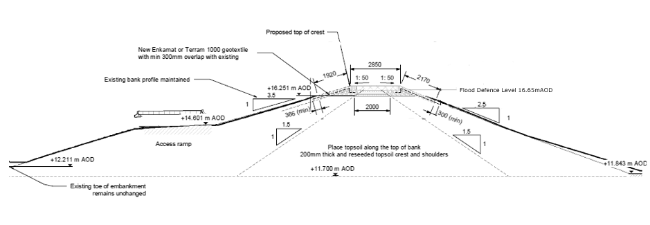
Image: Environment Agency
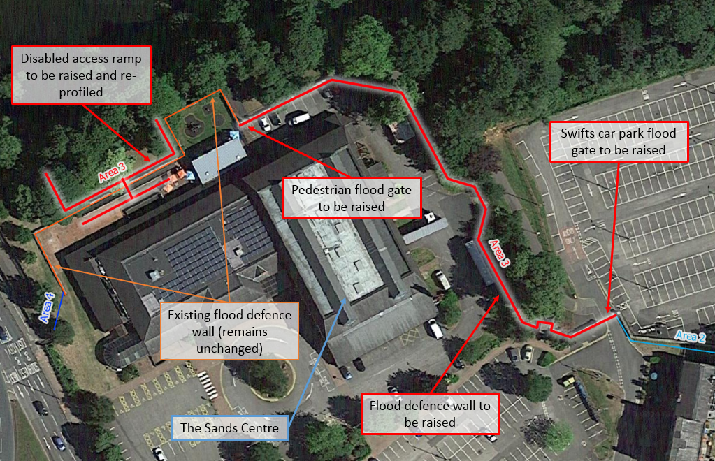
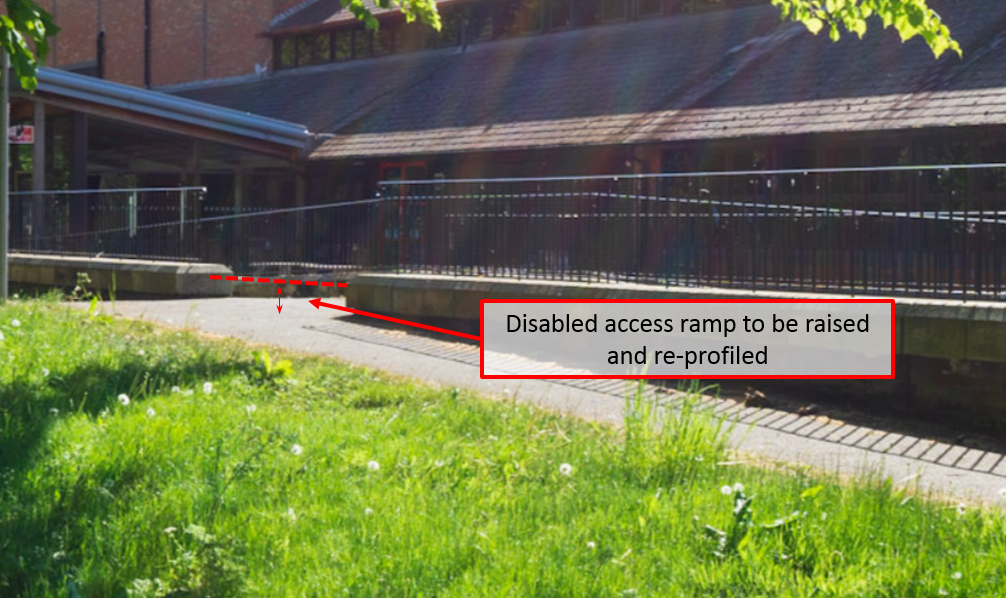
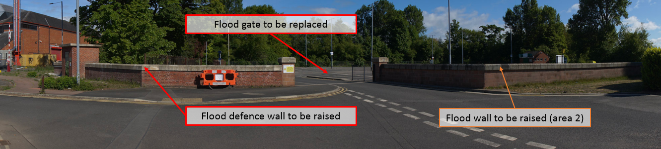
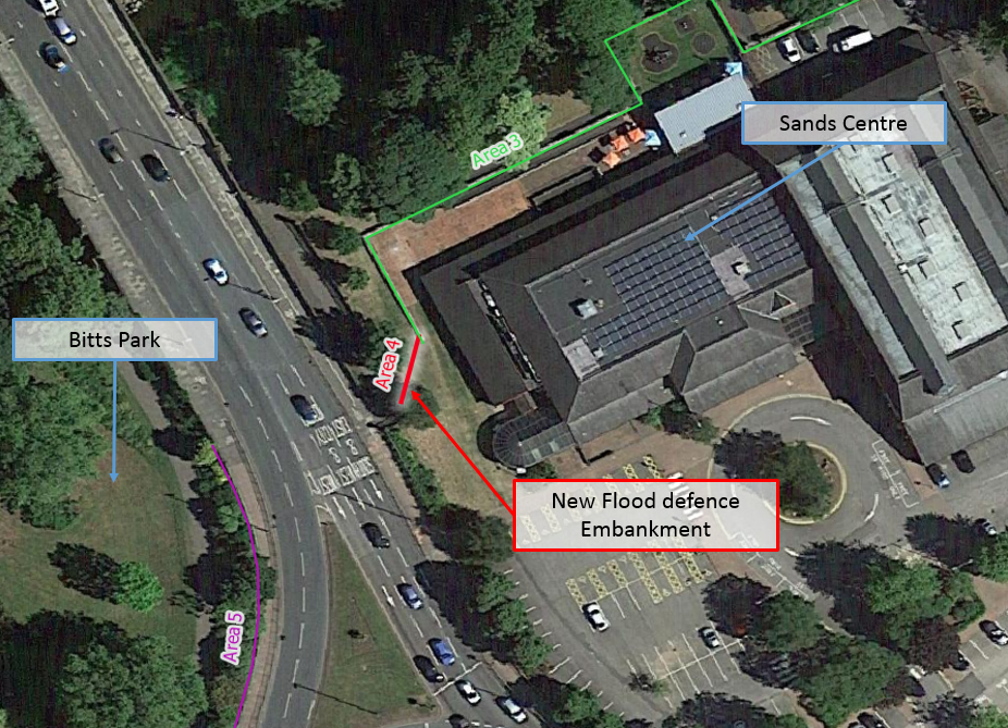
Area 3 involved raising of the defences around the Sands Centre, which overtopped during Storm Desmond, by approximately 0.3m. This involved replacing two flood gates (one pedestrian and one vehicular), raising approximately 150m of flood wall as well as raising and re-profiling the disabled access ramp which links the Sands centre to the Hadrian’s Wall footpath alongside the River Eden.
The construction work in this area involved:
Work in this area did not form part of the planning application. As it was a modification to the existing flood defence structure it could be delivered within the existing permitted development powers.
The completed defence is visually similar to the pre-existing defence.
Text within red boxes on any maps and annotated photographs illustrate proposed works that were undertaken in the area.
Construction work in this area is complete.
To complete this work the Environment Agency needed to:
Weather – This element of the work was not particularly weather sensitive, however, particularly inclement weather or exceptionally high river levels could have resulted in delays.
Sands Centre redevelopment – To construct the new flood defences in area 3 the Environment Agency worked alongside the Sands Centre redevelopment team. The project teams coordinated closely to ensure both projects could be delivered as planned.
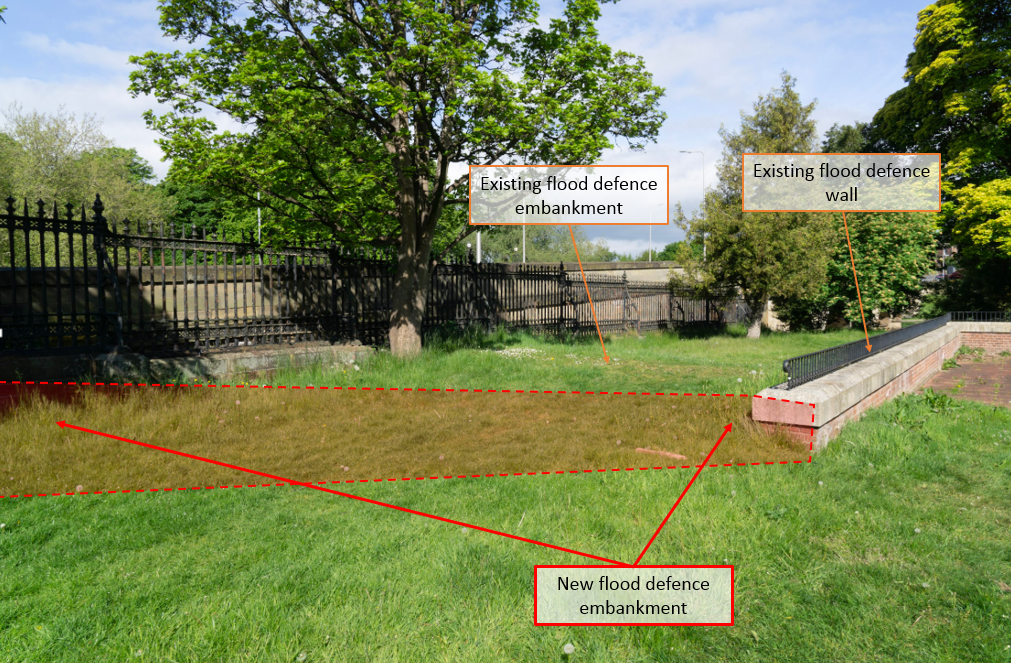
The pre-existing embankment in this location was slightly lower than the crest level of the adjacent flood wall. These works mean that there is a continuous defence level from the existing wall around the northern side of the Sands Centre to Eden Bridge. The Environment Agency constructed a new embankment which connects to a slightly higher section of the footpath leading down from Eden Bridge. The new embankment is therefore on a diagonal alignment.
The construction work in this area involved:
Work in this area formed part of the planning application.
Text within red boxes on any maps and annotated photographs illustrate proposed works that were undertaken in the area.
Construction work in this area is complete.
To complete this work the Environment Agency needed to:
Weather – This element of the work is not particularly weather sensitive, however, particularly inclement weather or exceptionally high river levels could have resulted in delays.
Sands Centre redevelopment – To construct the embankment the Environment Agency worked alongside the Sands Centre redevelopment team. Their project teams coordinated closely to ensure both projects were delivered as planned.
UU water main – United Utilities have a water supply main that runs under the embankment. The Environment Agency worked closely with their engineers to ensure this was adequately protected.
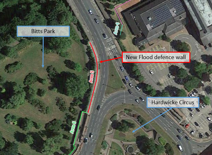
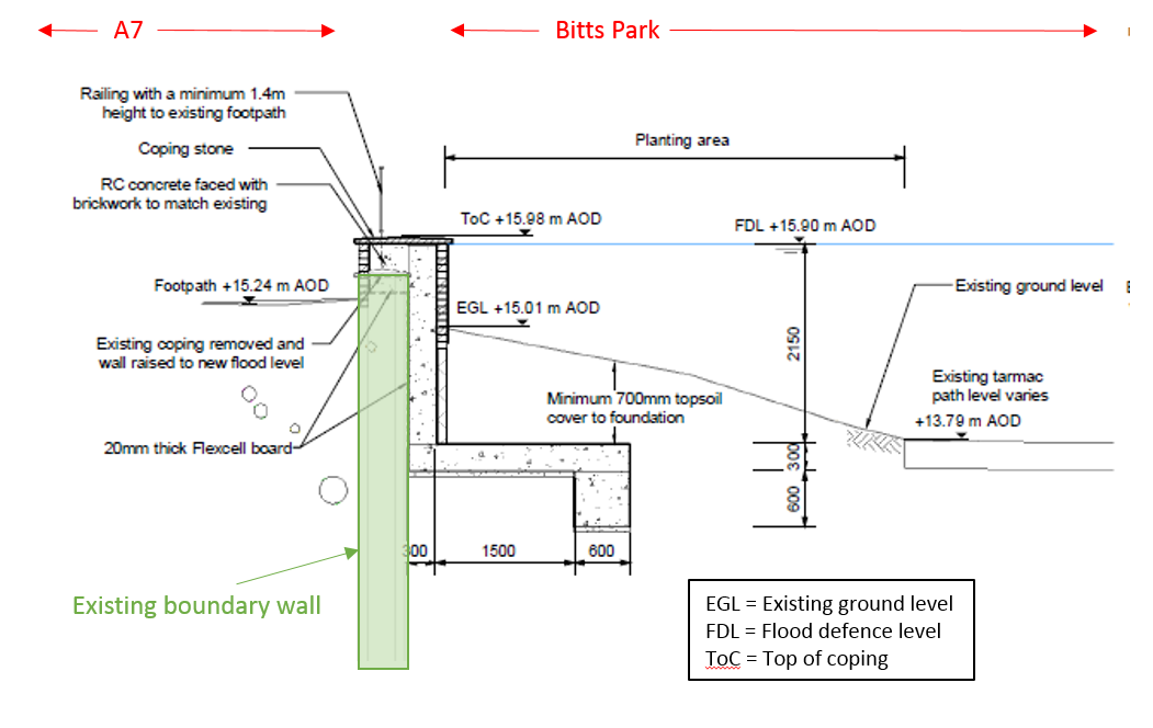
This is one of the few parts of this scheme where the Environment Agency have constructed an entirely new flood defence wall. This extends the existing defence from the northern side of the subway (where it previously stopped) another 105m towards Eden Bridge. From this point onwards, towards the bridge, the road level remains higher than the new flood defences.
The foundations of the new flood defence wall were constructed in the border of Bitts Park abutting the existing short wall which forms the boundary between the park and the pavement. These, along with the new wall, were constructed of reinforced concrete and extend approximately 2m below ground level.
The construction work in this area involved:
Work in this area formed part of the planning application.
Text within red boxes on any maps and annotated photographs illustrate proposed works that were undertaken in the area.
Construction work in this area is complete.
Planting – Some further planting will be undertaken in this area in the Autumn.
To complete this work the Environment Agency needed to:
Service Diversion – There is an abandoned drinking water supply pipe which currently runs under this section of the defence. The Environment Agency are working with United Utilities to ensure they are satisfied with the design and construction methods.
Weather – This element of the work is not particularly weather sensitive, however, particularly inclement weather or exceptionally high river levels could have resulted in delays.
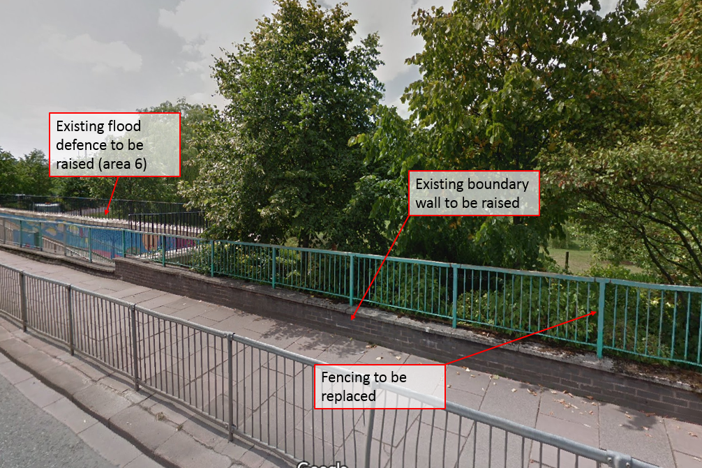

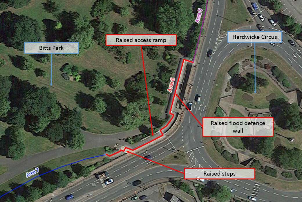
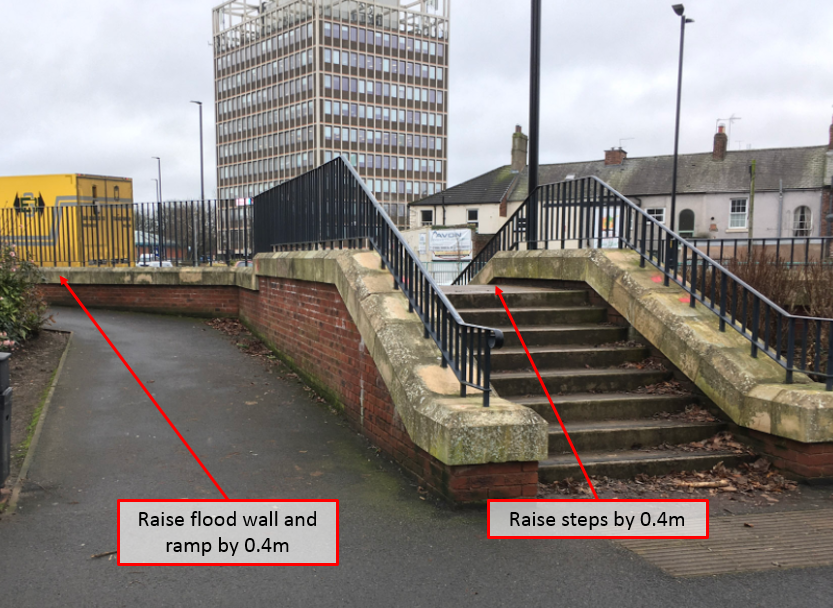
The flood defence wall which runs behind the subway entrance alongside the Bitts Park access ramp and steps was raised by 0.4m. The crest of both the access ramp and the steps were also raised as these form part of the flood defence.
The construction work in this area involved:
Work in this area did not form part of the planning application. As it was a modification to the existing flood defence structure it could be delivered within the existing permitted development powers.
The completed defence is visually similar to the pre-existing defence.
Text within red boxes on any maps and annotated photographs illustrate proposed works that were undertaken in the area.
Construction work in this area in complete.
To complete this work the Environment Agency needed to:
Weather – This element of the work was not particularly weather sensitive, however, particularly inclement weather or exceptionally high river levels could have resulted in delays.
Service protection – A United Utilities sewer pipe runs under the existing defence and the Environment Agency worked with United Utilities to ensure that the design and construction of the defence provided adequate protection to this sewer.
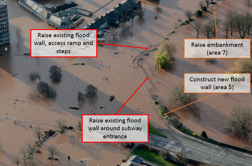


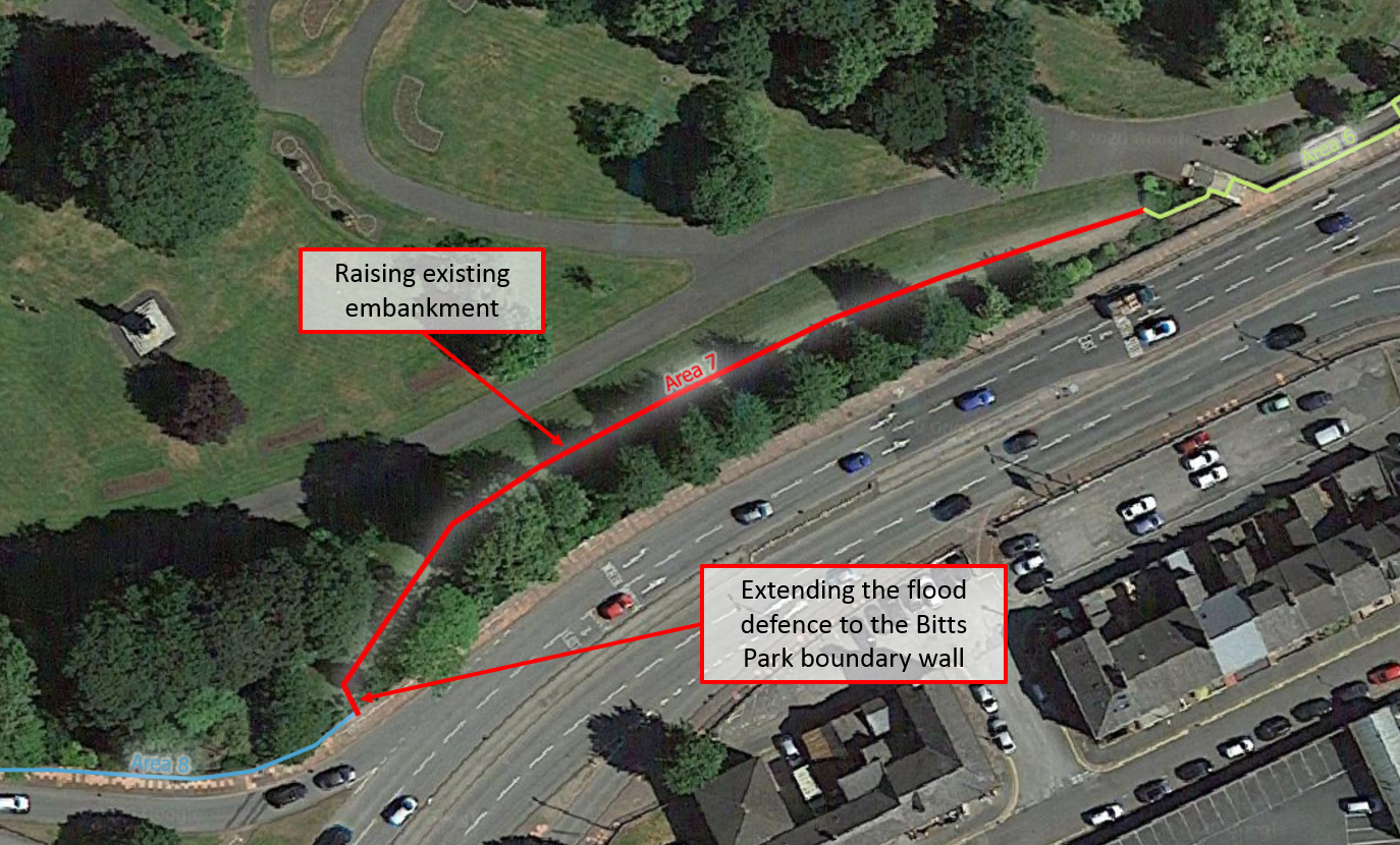
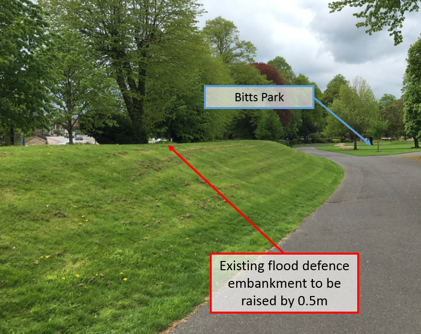
The pre-existing flood defence embankment has been raised by approximately 0.5m, and extended at the western (Castle) end to tie into the Bitts Park boundary wall (area 7).
The construction work in this area involved:
The new flood defences and landscaping in this area look visually similar to what was present before the scheme.
Work in this area did not form part of the planning application. As it was modifications to the existing flood defence structures it could be delivered within the existing permitted development powers.
Text within red boxes on any maps and annotated photographs illustrate proposed works that were undertaken in the area.
Construction work in this area is largely complete, however, following the main construction phase the Environment Agency undertook detailed confirmatory surveys and assessments of the scheme. In area 7 they have identified the need to slightly extend the embankment at its eastern extent. This work is relatively minor and will be completed during Autumn 2021.
To complete this work the Environment Agency needed to:
Weather – This element of the work involved working on an earth and clay embankment and could not be undertaken during very wet weather.
Service protection – A sewer pipe runs under the existing embankment and the Environment Agency worked with United Utilities to ensure that the design and construction of the defence provides adequate protection to this sewer.
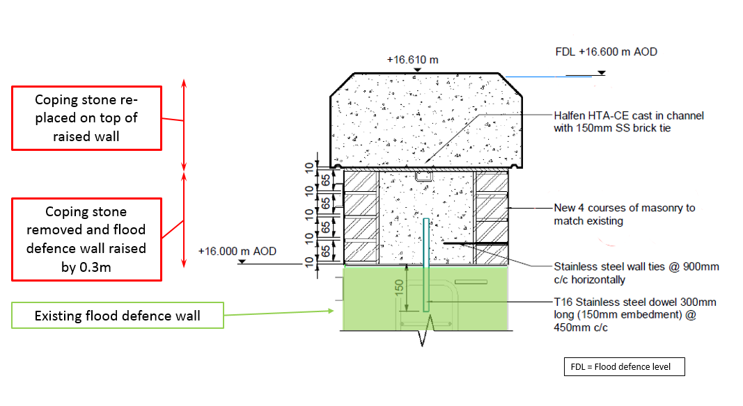
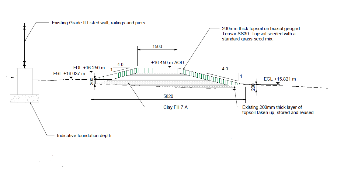
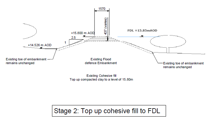
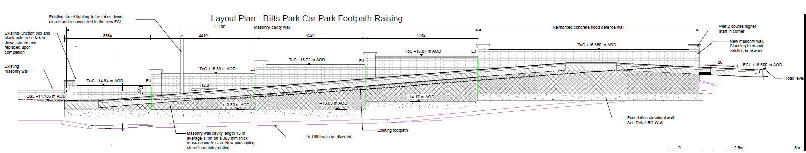
EGL = Existing ground level
FDL = Flood defence level
AOD = Above Ordnance Datum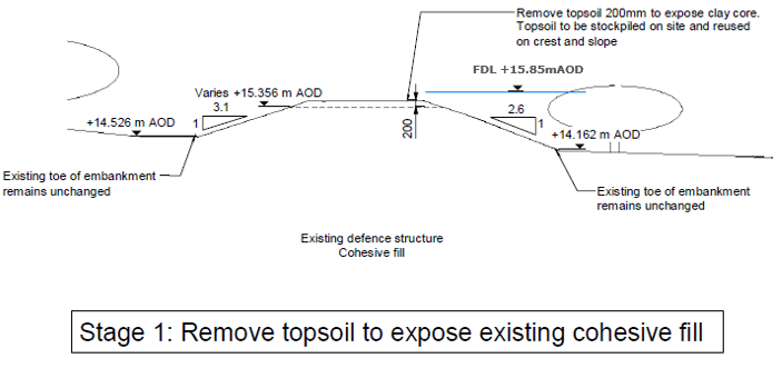


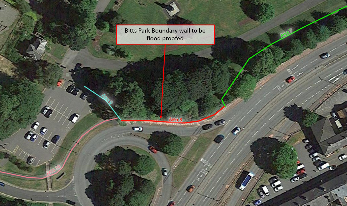
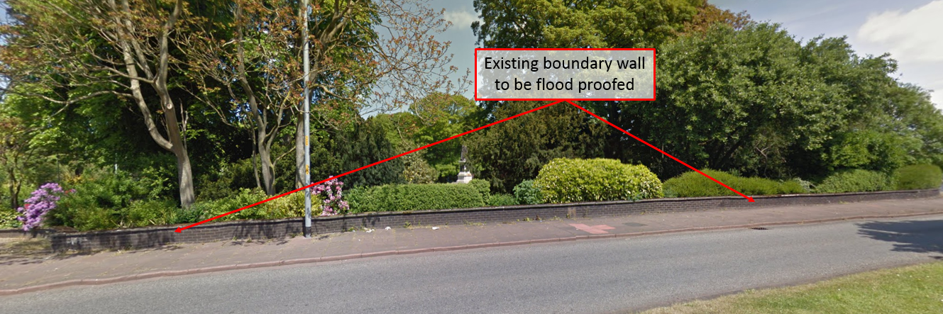
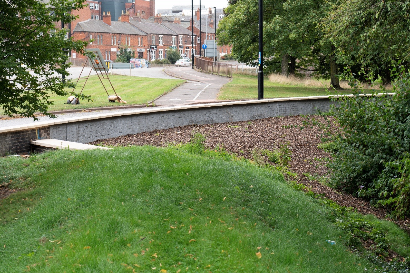
The existing Bitts Park boundary wall has been renovated and waterproofed to create a short flood defence wall.
The process involved:
Work in this area did not form part of the planning application. As it was a modification to the existing flood defence structure it could be delivered within the existing permitted development powers.
The completed defence appears visually very similar to the pre-existing wall.
Text within red boxes on any maps and annotated photographs illustrate proposed works that were undertaken in the area.
Construction work in this area is complete.
Some further planting in this area will be undertaken during Autumn 2021.
To complete this work the Environment Agency needed to:
Weather – This element of the scheme was not highly weather dependent although particularly adverse conditions could have delayed delivery.
The works in area 9 replaced the existing Bitts Park boundary wall from the entrance to Bitts Park to the corner adjacent to Castle Way. This was required to retain the newly raised Bitts Park car park flood embankment (area 10) and to facilitate re-profiling the path down the Bitts Park entrance.
The construction work in this area involved:
The works proposed in area 9 formed part of the planning application.
Text within red boxes on any maps and annotated photographs illustrate proposed works that were undertaken in the area.
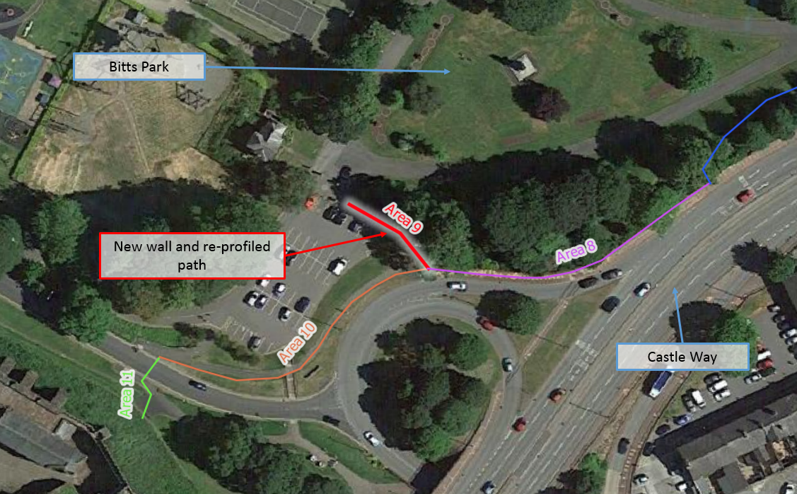
Construction work in this area is largely complete; however, following the main construction phase the Environment Agency undertook detailed confirmatory surveys and assessments of the scheme. In area 9 the slope across the path was found to be too steep potentially making it difficult to negotiate for some users. The path has therefore been closed and will be re-profiled. It is expected that this work will be completed in Autumn 2021.
To complete this work the Environment Agency needed to:
Weather – This element of the work is not particularly weather sensitive, however, particularly inclement weather or exceptionally high river levels could have resulted in delays.


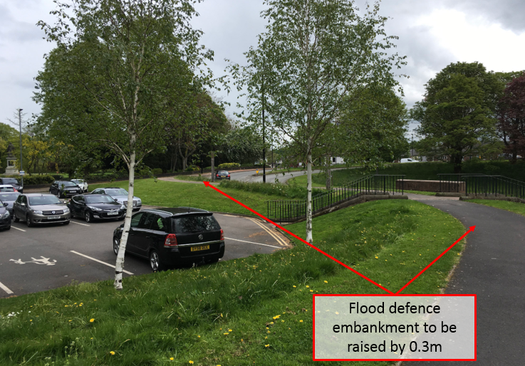
The existing flood defence embankment has been raised by approximately 0.3m.
The process involved:
Work in this area did not form part of the planning application. As it is a modification to the existing flood defence structure it could be delivered within the existing permitted development powers.
The completed, raised, defence is visually similar to the existing embankment with crossing points and pathways replaced.
Text within red boxes on any maps and annotated photographs illustrate proposed works that were undertaken in the area.
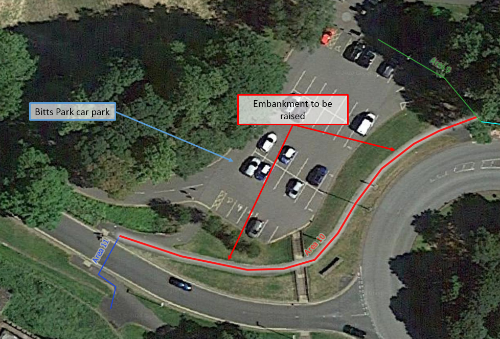
Construction work in this area is complete.
To complete this work the Environment Agency needed to:
Weather – This element of the work involves working on an earth and clay embankment and could not be undertaken during very wet weather.
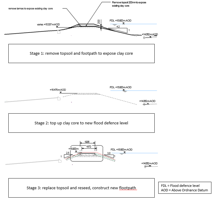

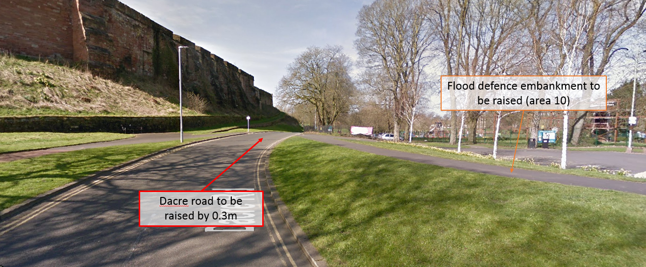
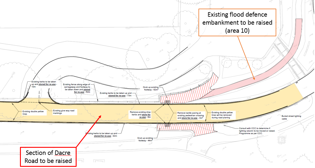
The construction work in area 11 was required to continue the new flood defence level to the high ground of the Castle. The crest of Dacre Road, at the pedestrian crossing, was raised by 0.3m. To achieve this, approximately 100m of road was re-profiled and re-surfaced.
There was also some raising of the footpaths on either side of the road to ensure that a continuous flood defence level is provided to the high ground of the castle.
The construction work in this area involved:
The proposed works in area 10 formed part of the planning application.
Text within red boxes on any maps and annotated photographs illustrate proposed works that were undertaken in the area.
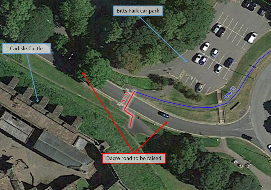
Construction work in this area is largely complete; however, following the main construction phase the Environment Agency undertook detailed confirmatory surveys and assessment of the scheme. In area 11 they have observed that a puddle forms in a slight depression on the road crossing at the crest of the embankment. To alleviate this the road surface in this area will be re-profiled to ensure that rainwater can drain freely away. This work will be undertaken in Autumn 2021.
To complete this work the Environment Agency needed to:
Weather – This element of the work is not particularly weather sensitive, however, particularly inclement weather or exceptionally high river levels could have resulted in delays.

In order to construct phase 2 of Carlisle Flood Risk Management Scheme the Environment Agency will need to set up two compounds. The first of these will be located in the southern portion of the Swifts Car Park (adjacent to the flood defence) and will occupy approximately 15% of the car park with the rest of the car park remaining open for public use. The second compound will be located in the Bitts Park car park and the adjacent area previously used as a high ropes course. This compound will occupy all of the car park and there will be no public car parking available at this location for the duration of the construction work. Alternative car parking for Bitts Park is available in the Castle Car Park (accessed from Devonshire Way).
These compounds will be used to store construction materials and equipment as well as providing essential welfare facilities for the construction staff. Both compound areas will be closed to the public from early August until construction of the scheme is complete at the end of March 2021.
A significant proportion of flood defences which are being raised are located along the boundary of Bitts Park. It is therefore unavoidable that this construction work will impact access to the park. The Environment Agency are however conscious of the importance of retaining public access to this park and have made every effort to minimise the impact on access to the park.
The maps here show the footpath closures that are essential in order to construct phase 2 of the Carlisle Flood Risk Management Scheme. Any paths not marked up on these plans are unaffected by the works and will remain open throughout.
The Environment Agency have looked at over 60 different options and combinations of options for Carlisle, as well as having three public consultations where they have consulted and shared the identification of these. This preferred option for phase 2 has been selected as the most economically viable, technically feasible, environmentally sustainable and socially acceptable of all the options considered.
Eden Bridge is a large and historic bridge which spans the River Eden with five arches. The approach to the bridge, partially on the northern side of the river, is partially obstructed by gravel bars which have been deposited by the river. One option considered to manage flood risk in the city was to remove some of this gravel in order to increase the rate at which flood waters could pass under the bridge. To assess the effectiveness of this option to manage flood risk the Environment Agency first needed to consider how much benefit it could provide. The starting point for this is to understand how the bridge interacts with flood waters and how much influence the bridge has on peak flood levels.
The bridge does undoubtedly represent an impediment to flood flows and as a result, it causes peak water levels upstream of the bridge to be higher than they would be if the bridge were not there. The factors that cause this include the structure of the bridge itself (including the abutments and piers, which are effectively a blockage to flood flows), the narrowing of the floodplain at this location and any gravel deposits which further reduce the area under the arches.
However, photos taken of both the upstream and downstream faces of the bridge during Storm Desmond show that water levels were not significantly lower downstream of the bridge; in both cases they are just below the top of the arches (which are at the same height on both sides of the bridge).
Both the hydraulic model and the water levels that were recorded during Storm Desmond indicate that the peak water levels were between 0.4m and 0.5m higher 100m upstream of the bridge than 100m downstream. This is consistent with the photos. During storm Desmond the defences downstream of the bridge were overtopped more significantly than those upstream of the bridge, suggesting that the bridge did not have a significant impact on the degree of flooding during this event.
Based on the assessments excavating the depositional gravel bars on right bank of the river would reduce peak flood levels upstream of the bridge by less than 3cm during an event the scale of Storm Desmond.
This analysis shows that the benefit, in terms of flood risk, of increasing conveyance under the bridge are not significant and could not rival the benefits that can be delivered by raising the defences in the way proposed.
There are also many other factors that need to be considered when selecting a preferred option for a flood risk management scheme. Other factors which affected the decision at Eden Bridge include the sheer volume of material that would need to be removed from the river (making this an expensive exercise) as well as the work involved to remove these gravels without a detrimental impact on the natural environment or heritage.
Click images to enlarge.


The Environment Agency have designed this upgraded flood defence scheme to provide protection from a flood that currently has a 0.5% probability of occurring in any given year.
As the climate continues to change as a result of global warming they predict that large floods will become increasingly common. They predict within the next 100 years a flood of this magnitude could have a 2% chance of occurring in any given year.
NFM is a longer term solution which will help to mitigate the impacts of climate change. It is being used in conjunction with other more traditional engineered measures to help reduce flood risk. The Environment Agency have already identified several natural flood management projects in the Eden catchment that they have been supporting and will continue to support.
The majority of the Carlisle Phase 2 Flood Risk Management Scheme involves raising the existing flood defences and will be delivered through the permitted development rights. However, there are four areas (Areas 4, 5, 9 and 11) which do require planning permission. The application for these works will be submitted to Carlisle City Council by the end of August 2020.
Unfortunately, yes. It is unavoidable that some trees will be removed in order to facilitate the construction of these flood defences. The Environment Agency are however making every effort to minimise this. The areas where some trees will be removed are the borders of Bitts Park within areas 5 and 9.
The design team estimate that a maximum of 27 trees may need to be removed and a further 5 trees are considered to be at risk of removal. The area where most trees need to be removed is area 5 where 9 trees will have to be removed in order to construct the new flood wall and it’s foundations. Throughout the construction of the scheme the contractors will be seeking to minimise the number of trees that need to be removed and hope that some of these can be retained.
Any trees that are removed will be replaced at a ratio of 5 to 1, close to where they have been removed or in another nearby location, both of which will be agreed with the Carlisle City Council Green Spaces team.
Yes. Some elements of the construction process will require temporarily lowering the crest of the existing defence (for example removing the coping stones from the top of the flood wall before raising the stem of the wall and replacing the coping stones again). Where this is necessary this work will be undertaken in short sections and processes will be in place to ensure the existing defence height can be reinstated at short notice if high river levels are expected.
No. Understanding how risk changes in different parts of a community during the delivery of a large complex scheme is important. The Environment Agency do not believe that the phase 2 works they have identified changes risk to properties elsewhere in Carlisle.
The Environment Agency are working with Carlisle City Council to provide the following environmental enhancements within the City of Carlisle.
The UK Government classes the construction of flood defence schemes as critical work and the Environment Agency remains determined to deliver the additional flood protection to Carlisle that this scheme will provide as soon as possible. However, they will only do this so long as their construction and supply chain activities can be undertaken in accordance with current government guidelines.
The proposed construction techniques do not involve the use of particularly heavy or noisy plant. However, there will be some noise associated with normal construction activity, for example moving and operating plant and equipment. Occasionally there will be some limited activity which generates more noise, for example cutting the existing coping stones from the top of the flood wall and drilling holes in the copings for new fencing mounts. However these activities are relatively limited in duration and will not be undertaken outside of normal working hours.
The Environment Agency’s contractors will typically work on site Monday to Friday between the hours of 07:30 and 18:00.
It is not possible for the Environment Agency and its contractors to deliver work across the whole city at the same time. In order to make delivery of the work required across the city more manageable and reduce the impact on the city the work will be undertaken in phases. Phase 1 includes works to the east of the city and alongside the River Petteril, construction of this phase is already underway. Phase 2, this phase, will provide increased flood protection from the River Eden to the centre of the city. Phase 3 then will improve the standard of protection to the west of the city including areas at risk of flooding from the River Caldew such as Denton Holme and Willowholme, the construction on this phase of the scheme is planned to start in 2021.
The Environment Agency are working closely with a number of partner organisations. Some specific examples include:
They have also created something called the Carlisle Strategic Liaison Panel where key issues that involve more than one organisation are considered. Working jointly with these organisations for specific elements of the scheme should help with costs, programmes and reduce wider disruption across the city.
If you would like to provide any feedback on the information provided or would like to contact the Carlisle Flood Risk Management Scheme project team please use the following email address: [email protected].


